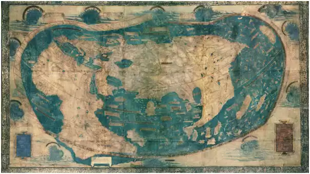
Da Greg Martinez riceviamo e pubblichiamo questo articolo e la relativa mappa, che risalirebbe a tempi antichissimi. Non siamo talmente esperti per poter dire se si tratta di un documento attendibile o meno, tanto più che le carte hanno sempre rappresentato in passato una questione controversa e politicamente fondamentale in vista di possibili conquiste ed espansioni. Quando il globo non era ancora stato completamente conosciuto E percorso e in una disputa da agenti segreti nella quale non sono mai mancati i falsi. Come in epoche successive. Chi avesse qualcosa da dire in proposito non ha che segnalarcelo.
Un Mapa de Hace 1000 Años Muestra Más Tierras
El periódico Gaceta de Hawai, publicó el viernes 11 de enero de 1907 un mapa de hace 1000 años junto con un artículo. En la imagen se observan tierras más allá de la Antártida.
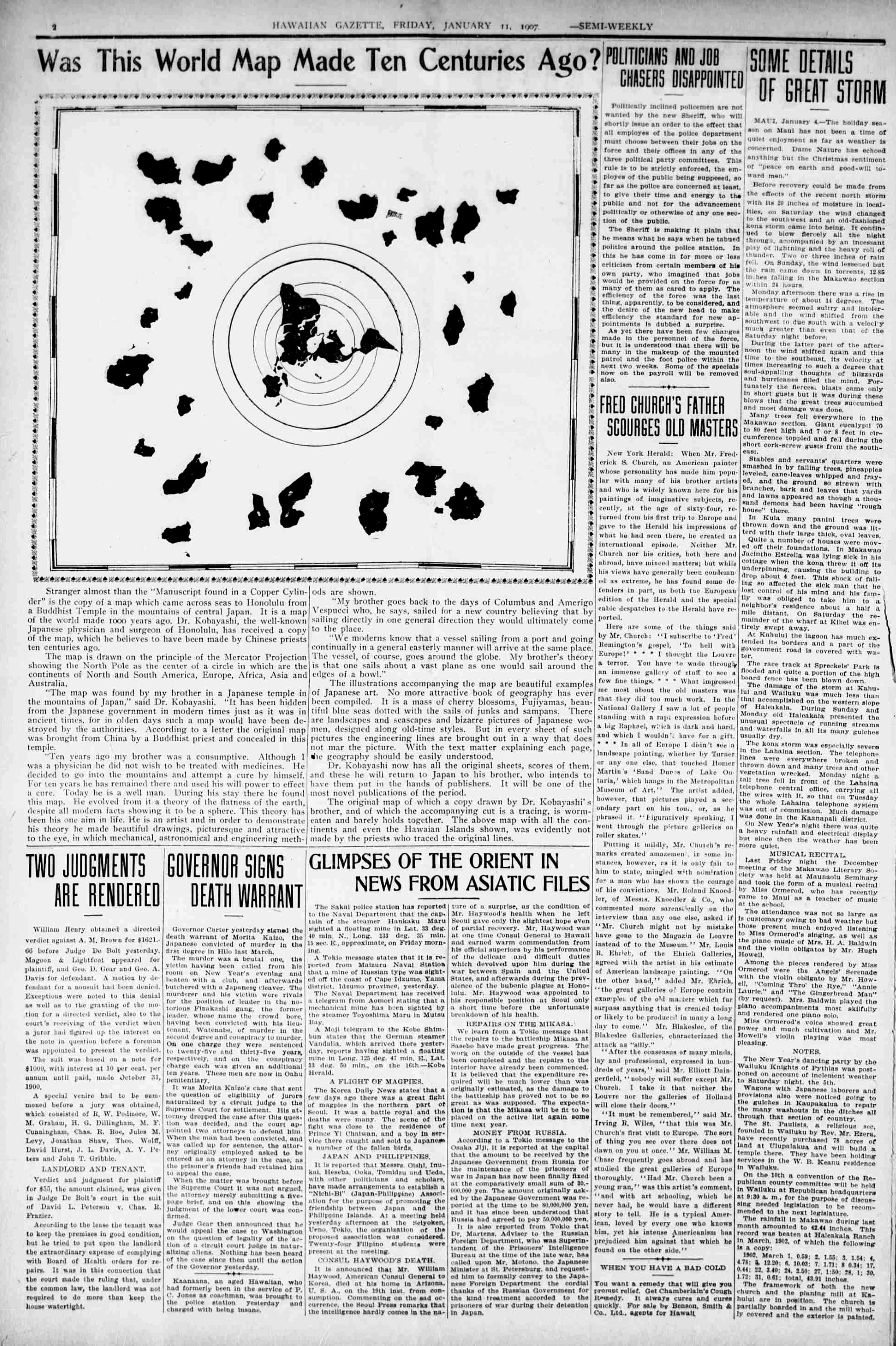
Stranger almost than the “Manuscript Found in a Copper Cylinder” is the copy of a map which came across seas to Honolulu from a Buddhist Temple in the mountains of central Japan. It is a map of the world made 1000 years ago. Dr. Kobayashi, the well-known Japanese physician, and surgeon of Honolulu has received a copy of the map, which he believes to have been made by Chinese priests ten centuries ago. The map is drawn on the principle of the Mercator Projection showing the North Pole as the center of a circle in which arc the continents of North and South America, Europe, Africa, Asia, and Australia. “The map was found by my brother in a Japanese temple in the mountains of Japan,” said Dr. Kobayashi. “It has been hidden from the Japanese government 111 modern times just as it was in ancient tunes, for in olden days such a map would have been destroyed by these authorities". According to a letter the original map was brought from China by a Buddhist priest and concealed in this temple.“ Ten years ago my brother was a consumptive. Although I was a physician he did not wish to be treated with medicines. He decided to go into the mountains and attempt a cure by himself. For ten years he has remained there and used his will power to effect a cure. Today he is a good man. During his stay there he found this map. Lie evolved from it a theory of the flatness of the earth, despite all modern facts showing it to be a sphere. This theory has been his one aim in life. He is an artist and in order to demonstrate his theory, he made beautiful drawings, picturesque, and attractive to the eye, in which mechanical, astronomical, and engineering methods are shown. “My brother goes back to the days of Columbus and Amerigo Vespucci who, he says, sailed for a new country believing that by sailing directly in one general direction they would ultimately come to the place.“ We moderns know that a vessel sailing from a port and going generally in a continually easterly manner win arrive at the same place. The vessel, of course, goes around the globe. "My brother’s theory is that one sail about a vast plane as one would sail around the edges of a bowl.” The illustrations accompanying the map arc beautiful examples of Japanese art. No more attractive book of geography has ever been compiled. It is a mass of cherry blossoms, Fujiyamas, beautiful blue seas dotted with the sails of junks and sampans. There are landscapes and seascapes and bizarre pictures of Japanese women, designed along with old-time styles. But in every sheet of such pictures, the engineering lines are brought out in a way that does not mar the picture. With the text matter explaining each page, the geography should be easily understood. Dr. Kobayashi now has all the original sheets, scores of them, and these he will return to Japan to his brother, who intends to have them put in the hands of publishers. It will be one of the most novel publications of the period. The original map of which a copy drawn by Dr. Kobayashi’s brother, and of which the accompanying cut is a tracing, is worm-eaten and barely holds together. The above map with all the continents and even the Hawaiian Islands are shown, was evidently not made by the priests who traced the original lines.
Ringrazio Mario Rossi che ha tradotto l'articolo pubblicato dal quotidiano The Hawaian Gazette del gennaio 1907:
Il "Manoscritto trovato in un cilindro di rame" è la copia di una mappa che attraversò i mari fino a Honolulu proveniente da un tempio buddista nelle montagne del Giappone centrale. È una mappa del mondo fatta 1000 anni fa. Il dottor Kobayaschi, noto medico e chirurgo giapponese di Honolulu, ha ricevuto una copia della mappa, che crede sia stata realizzata da sacerdoti cinesi dieci secoli fa.
La mappa è disegnata secondo il principio della proiezione di Mercatore che mostra il Nord e il Sud America, l'Europa, l'Africa, l'Asia e l'Australia. "La mappa è stata trovata da mio fratello in un tempio giapponese sulle montagne del Giappone", ha detto il dottor Kobayashi. "È stata nascosta al governo giapponese nei tempi moderni proprio come nei tempi antichi, perché anticamente una mappa del genere sarebbe stata distrutta dalle autorità". Secondo una lettera la mappa originale è stata portata dalla Cina da un prete buddista e nascosta in questo tempio.
"Dieci anni fa mio fratello era malato. Anche se ero un medico non voleva essere curato con le medicine. Decise di andare in montagna e tentare una cura da solo. Per dieci anni è rimasto lì e ha usato la sua forza di volontà per curarsi. Oggi sta bene. Durante la sua permanenza laggiù ha trovato questa mappa. Dalla quale si è sviluppata la teoria della terra piatta, a dispetto di tutte le prove scientifiche che dimostrano che la terra è una sfera. Questa teoria è stata il suo scopo nella vita. È un artista e per dimostrare la sua teoria ha realizzato disegni bellissimi. Mio fratello risale ai giorni di Colombo e Amerigo Vespucci che navigarono per un nuovo paese credendo che navigando in una direzione alla fine sarebbero arrivati alla meta.
Noi moderni sappiamo che una nave che salpa da un porto e procede senza sosta unicamente verso est tornerà alla fine nel luogo da dove è partita. La nave, ovviamente, avrà compiuto il giro del mondo. La teoria di mio fratello è che si naviga su un vasto piano come si naviga sui bordi di una sfera. Le illustrazioni che accompagnano la mappa sono bellissime, veri esempi di arte giapponese. Non è mai stato compilato un libro di geografia più attraente. È un ammasso di fiori di ciliegio, Fujiyamas, bellissimi mari azzurri punteggiati da vele, da giunche e canoe. Ci sono paesaggi terrestri e paesaggi marini e immagini bizzarre di donne giapponesi, disegnate secondo lo stile di altri tempi, in modo che non si alteri la bellezza dell’ insieme comprese le indicazioni geografiche. Un testo accompagna ogni pagina in modo che la mappa dovrebbe essere facilmente decodificata. Il dottor Kobayashi possiede tutti i fogli originali, che sono decine, e li riporterà in Giappone da suo fratello, che intende consegnarli ad un editore. Sarà una delle pubblicazioni più innovative nella storia della geografia.
La mappa originale da cui deriva la copia disegnata dal fratello del dottor Kobayashi e di cui il testro che l'accompagna è una traccia, è mangiata in parte dai vermi e la legatura è molto rovinata. La mappa che presenta tutti i continenti e persino le isole hawaiane, evidentemente non è stata fatta dai sacerdoti che hanno tracciato le linee originali.